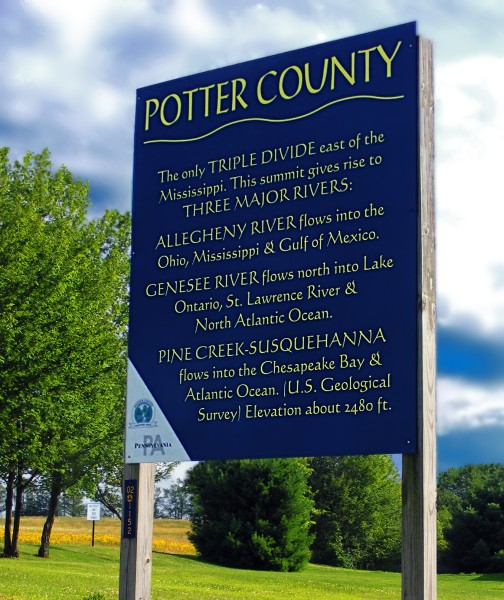
There’s a unique place in north central Pennsylvania at the top of three major watersheds. It’s called The Triple Divide.
When a raindrop falls there it can split three ways:
- In one direction, it flows west to the Allegheny River, down the Mississippi watershed and into the Gulf of Mexico.
- Or it flows north to the Genesee River, Lake Ontario, the Saint Lawrence watershed and into the north Atlantic.
- Or it flows southeast to Pine Creek, the Susquehanna River, Chesapeake Bay and the Atlantic Ocean.
The spot is in Ulysses Twp, Potter County, Pennsylvania and is marked with the sign pictured above.
The location itself is unremarkable. It’s not a big mountain, just a hill on the Allegheny Plateau near the New York state line. It’s not even the highest point in Pennsylvania, but it spawns three major North American rivers: the Mississippi, the St. Lawrence and the Susquehanna.
According to Dr. Robert N. Andersen at University of Wisconsin Eau Claire, “Triple divide points are ubiquitous in North America. Wherever there is a confluence of two streams there is a Triple Divide Point uniquely associated with the confluence. ” Then he uses Pittsburgh’s confluence of the Allegheny and Monongahela Rivers to describe how to find a triple divide near us.
Beginning at the Point in Pittsburgh, trace the border of the Allegheny and Monongahela watersheds, moving upstream. Eventually you reach the place where the border ends. At that point in Somerset County, east of Berlin, PA, is a triple divide that drains the Mississippi (via the Conemaugh and Youghiogeny), the North Branch of the Potomac, and the Susquehanna River (via the Juniata).
In the western U.S. there are triple divides that drain to both the Atlantic and Pacific. And somewhere in Canada there’s an oceanic triple divide where a raindrop can split and flow to the Arctic, the Atlantic and the Pacific Oceans.
Follow a raindrop uphill and you’ll eventually find a triple divide.
(photo by Nicholas A. Tonelli on Wikimedia Commons. Click on the image to see the original and explore the location on Google Maps)

Now THAT is cool!
Unrelated to blog entry but of interest to all bird enthusiasts. Ibird Pro Guide app for iPhone/ipad on sale today for $4.99 (save $10.00) at iTunes Store
This entry is well researched. I live in Potter County as one of the few who don’t have a car and see their surroundings through photos and write ups like this.
Well look at that pretty sign. I visited that “summit” in 2014 and I never did see this sign. It appears to be a little down the road.
I had a notion someday to take three river trips, each one starting from that point. At the start there’d be a fair amount of portage…
Very nice blog. I noticed one mistake. The Triple Divide is not in Genesee Township. I believe it is in Allegany Township.
Brent, you’re right that the PA Triple Divide isn’t in Gennessee Twp. I checked online and it’s listed in Ulysses Twp. http://www.peakbagger.com/peak.aspx?pid=7207 and Potter County Triple Divide Point on Google Maps
I made the correction.
This is really so interesting. Thank you for teaching it to me!
https://www.peakbagger.com/peak.aspx?pid=7350
East of Berlin PA
Correction by Kate St. John 2024-09-01: This is the Mississippi (via Allegheny R.) – St. Lawrence (via Genessee R.) – Chesapeake (via Susquehanna R.) Triple Divide where the three watersheds touch, per the comment below by Kevin (Retired Hydrologist)
To clarify, it’s the Mississippi (via Allegheny R.) – St. Lawrence (via Genessee R.) – Chesapeake (via Susquehanna R.) triple point.
Hydrologically, the Chesapeake Bay is the drowned estuary of the Susquehanna River, so the argument can be made that the Potomac was once a pre-ice age tributary of the Susquehanna. However, the Potomac receives no water from this triple point.