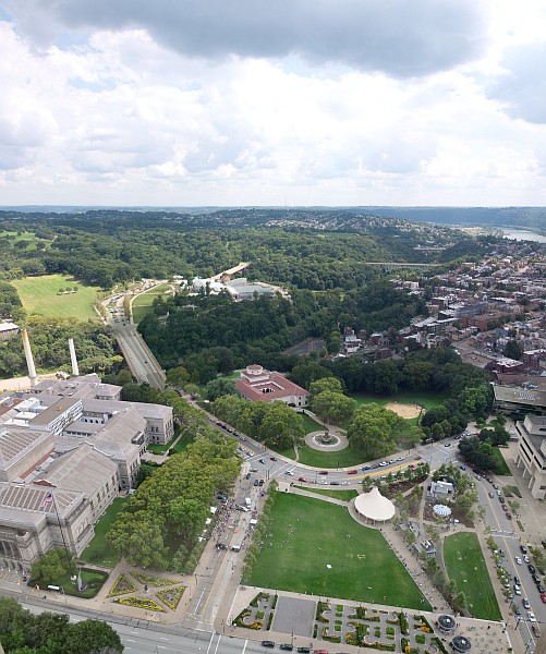
In good weather this is what Pitt’s peregrines see every day. From their perspective, the sky is the most interesting part.
We, of course, find the ground more interesting so it takes up most of the picture.
Between our two points of view is the horizon. Notice how the edge is flat, no hills or mountains.
Pittsburgh was the shore of an ancient inland sea (we used to be at the beach!) and our hills are actually erosion cuts into that flat landscape. The tops of the hills are what’s left of the original shore and they’re all the same height — about 1200 feet above sea level. Chestnut Ridge, 34 miles away, is the nearest mountain but it’s only 2,119 feet high, easy for birds to cross.
In the valley below the Cathedral of Learning, near the bottom right of this photo, is the Schenley Plaza tent where we sat during Fledge Watch. To a peregrine we humans are mere dots.
But they probably weren’t looking at us. They’re more interested in the sky. 😉
(photo by Chloe Fan on Wikimedia Commons. Click on the image to see the original. This photo was taken in 2009 prior to construction of The Porch restaurant. Can you tell what else has changed? )
p.s. See this comment for news of Pitt’s juvenile peregrine and the comments on yesterday’s blog for news from the I-79 Neville Island Bridge.

Even our major mountain ridges are the result of tectonic uplifting and are erosional remnants of the previously- formed Allegheny Plateau. Fascinating stuff. Thanks Kate!
I believe that the technical name for our “hills” is river terrace.
Sounds like an apartment building.