This month the Arctic sea ice melted to its smallest extent since satellite monitoring began. To see the dramatic change in only 33 years, click here and drag your mouse over the map.
We are used to hearing that the ice has melted, but the surprise this year is that no one thought it would happen this fast. Scientists thought the ice was thick and needed real warmth to melt. The models said it would take years to get this bad.
Apparently not. Apparently the ice is so thin that a strong wind can break it into slush that melts quickly.
And there was a strong wind.
The NASA animation above shows arctic wind circulation from August 1 to September 13. The long red arrows are the fastest winds.
Play the video and you’ll see a storm blow off the coast of Alaska on August 5 and swirl into a cyclone that broke up the ice and opened a large extent of the ocean.
This dramatic melting creates a gigantic feedback loop in which the lack of ice causes temperatures to rise and that causes more ice to melt.
A churning cyclone. A feedback loop. The situation is changing rapidly and brings to mind this verse:
Turning and turning in the widening gyre
The falcon cannot hear the falconer;
Things fall apart; the centre cannot hold;
Mere anarchy is loosed upon the world…”
— from The Second Coming by William Butler Yeats
(video from NASA/Goddard Space Flight Center Scientific Visualization Studio)
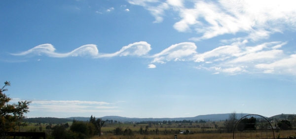
Yes, and it’s also the name of these very rare roll clouds that stretch as much as 1000 km. That’s 620 miles, the distance from Pittsburgh to Dallas, Texas!
I’ve never seen a morning glory cloud but the literature says they are low and tubular and appear to be rolling on their horizontal axis. They travel up to 60 kilometers per hour (37 mph) over a landscape that has no wind at ground level — until they arrive.
Morning glories bring wind with them and such great updrafts on the leading edge that glider pilots flock to the only place on earth where these clouds reliably occur: northern Australia’s Gulf of Carpentaria from August to November. Some have ridden these clouds for 500 km (310 mi).
Morning glory clouds can form (rarely) in response to severe thunderstorms but in Queensland they’re caused by sea breezes that flow onshore overnight at the Cape York Peninsula. The moist air comes from both east and west, meets in the middle over the peninsula, and rises into a stack of cold, turbulent air. Before dawn the stack is blown westward over the Gulf and causes ripples in the sky, each one carrying a long roll cloud.
Right now it’s spring in Australia and prime season for this rare phenomenon. In Burketown, Queensland the glider pilots awake before dawn, hoping for glory.
(photo by Mick Petroff via Wikimedia Commons. Click on the image to see the original)
The sunset was gorgeous last night after yesterday’s heavy rain. It reminded me of the old saying:
Red sky at night, sailor’s delight Red sky at morning, sailors take warning.
Though this saying is folklore, it’s a fairly accurate way to predict the weather.
When the sun is at a low angle, its light passes through more of the atmosphere and the blue-green wavelengths are stripped out, leaving mostly red. We see a pretty sunset when the reddish light reflects on the underside of clouds.
Clouds are key to the folklore weather prediction. They come from the west, they indicate moisture, and they might bring rain or storms.
As shown in last night’s photo, during a red sunset the clouds are close to us and the sky is clear in the far west. Clear skies in the west mean good weather is on its way.
During a red sunrise, the clouds are overhead or in the west but the clear skies have already passed over to the east. Morning clouds often indicate bad weather will arrive that day.
Taking a cue from last night’s sunset, I can safely predict that today will be a very fine day.
Banner clouds are stationary, orographic clouds that only form in high wind on the leeward side of an isolated, steep mountain. The Matterhorn, pictured above, is famous for them.
Banner clouds are so picky that we’ll never see them in western Pennsylvania simply because we have no isolated steep mountains.
… except …
Under the right moisture conditions a banner cloud can form above or just behind an airplane’s wings. Click here for an example.
Airplanes form banner clouds because there’s lower air pressure on top of their wings (to generate lift). The lower pressure results in lower temperature which results in condensation. Hence a cloud.
And for a really weird effect, check out this cloud around a fighter jet on the verge of breaking the sound barrier. The shape is so perfect it’s hard to call it a banner.
(photo by Zacharie Grossen on Wikimedia Commons. Click on the photo to see the original)
He also mentioned another orographic cloud that’s more common above Pennsylvania’s mountains: the wave.
This photo, taken by a glider pilot, shows two waves with a window over Bald Eagle Valley in north central Pennsylvania. The clouds are formed by the same wind pattern that creates lenticular clouds but instead of creating a lozenge-shape the long ridge produces a wave.
The best conditions often occur in the fall when a cold front brings northwest winds that hit the mountains at a 90 degree angle.
Pictured here the wind hits the Allegheny Front (on the left) and rises up to create the first wave. The air drops and creates a window over the valley, then rises again to create the second wave.
The pilot was flying north but I’m sure he saw hawks heading south using the same updraft to make their journey easy. (This photo was taken in autumn; the trees are changing color.)
It would have been a good day to be at the Allegheny Front Hawk Watch … as long as that cloud stayed well above the ground.
(photo by Dhaluza on Wikimedia Commons. Click on the photo to see the original and read more about it.)
Smooth clouds like this are my favorite because they look like lozenges or flying saucers. Sometimes they’re in compound shapes like this “hat” on Mt. Hood.
Lenticular clouds are most common near mountains because the wind hits the mountain, creates an updraft and becomes a large standing wave. When moisture condenses at the top of the wave, a stationary lenticular cloud forms there. The long lozenge shapes are usually perpendicular to the wind. They sure don’t look that way!
When the wind hits the mountain the waves look like this.
Notice the stationary clouds at crests A and B. The wind follows the shape of the mountain — twice! The updraft on the windward side of the mountain is provides uplift for glider pilots but the downdrafts can be deadly. There’s a lot of turbulence in those standing waves. Powered aircraft avoid them.
Pittsburgh rarely has lenticular clouds, though a front creates one occasionally.
For really cool clouds you have to visit the mountains.
(photo of cloud by Yapin Wu via Wikimedia Commons. Diagram of wave lift by Dake on Wikimedia Commons. Click the captions to see the originals.)
Though these look a lot like tornadoes they’re actually waterspouts, a phenomenon that fascinates me because I rarely see it.
Waterspouts don’t occur in Pittsburgh because they require lots of open water and just the right weather conditions. The best place to see them is in the Florida Keys but you don’t have to go that far at this time of year. They also form on the Great Lakes in late summer and early fall.
It’s possible to have a tornado over water, and yes it’s called a waterspout, but those are rare and dangerous. Tornadic waterspouts spin down from above but the really cool and much more common fair weather waterspouts spin up from the water to join the clouds. These require warm water, light winds, and humid air between the water and clouds. They go through five stages as described on this NOAA webpage:
Dark spot: A light-colored circle appears on the water’s surface surrounded by a dark area.
Spiral pattern: The dark spot spins and forms a spiral on the water around it.
Spray ring: The spinning makes water spray up around the dark spot. The spray forms a small “eye” like the eye of a hurricane.
Mature vortex: The spray ring gets organized and moves up to join the cloud. Now it looks like a waterspout. Sometimes you can see through its hollow center.
Decay: The funnel and spray vortex dissipate as warm water stops feeding them. The waterspout disappears.
The frequency of waterspout sightings on the Great Lakes has increased since NOAA began tracking them in 1957. There was a big outbreak of them on all five lakes September 27 to October 3 in 2003.
To learn more about waterspouts watch this dramatic video on the NOAA website.
(photo from NOAA by L. Glover. Click on the image to see the original)
NASA satellites have uncovered fascinating things about our world. One of them is shown on the spinning colored globe above.
This 15-second video is a composite map of lightning flashes observed by NASA OTD and LIS instruments from April 1995 through February 2003. Places with virtually no lightning are white, low levels are purple, then increasing amounts pass through the colors of the rainbow finally to red, black and white again.
Let’s slow it down and look more closely. Here’s NASA’s static map of the same thing showing the distribution of lightning per square kilometer per year.
It’s interesting to note the hot and cold spots:
Lightning is far less frequent over water than land.
It virtually never occurs at the poles.
Winter is a great lightning suppressor. I can count on one hand the number of times I’ve seen lightning while it’s snowing. Those times were quite memorable.
The worst place for lightning in the U.S. is Florida.
Be careful in Singapore, northern Columbia, and Kashmir.
There’s so much lightning in equatorial Africa that the map-maker ran out of colors!
Clearly it’s unsafe to play outdoors in the DR Congo. It’s hard to imagine how people cope with it there.
p.s. We had some sneaky lightning yesterday afternoon. A downpour, then the rain stopped and while everything was dripping… BAM! It sounded like an explosion. I’m glad I was indoors.
Except during storms, Pittsburgh is not a very windy place. This is especially true in July and August when our average wind speed drops to 9 mph and is usually from the west.
The direction of the “usual” wind is called the prevailing wind and it shapes our weather, rainfall, landscape and vegetation.
In places where the wind is strong the prevailing wind can be seen even when it isn’t blowing. Witness the trees in the photo above at Cardigan Bay in Wales.
From the equator (0o) to latitude 30o north and 30o south the prevailing winds are from the east. These are the trade winds that brought Christopher Columbus and cattle egrets(*) to the New World.
From latitudes 30o to 60o the prevailing wind is from the west. The westerlies returned the trading ships to Europe.
From latitudes 60o to the poles the prevailing wind is again from the east.
At any given point on earth the prevailing wind might not obey these rules due to location at a border latitude (30o, 60o), topography, or seasonal change.
Pittsburgh, at 40oNorth, has no stark topography so our prevailing wind obeys the general rule: it’s from the west or WSW.
We can see this on a wind rose that plots wind direction over time. Each data point is placed at its compass position. The more data points from that position, the longer the ray from the center.
Here’s a Pittsburgh wind rose from EPA showing our daytime wind for the seven months of ozone season (April 1 to October 31).
And what’s the wind like for those trees in the photo above? Right now it looks like this (scroll down to see the label “Cardigan Golf Club” and watch the wind swirl around the UK).
* Cattle egrets are originally from Africa. They flew to South American on their own — perhaps in a strong storm carried by the prevailing winds — the trade winds.
(photo of wind-shaped trees by Rudi Winter from Wikimedia Commons. Wind rose from epa.gov. Click on the captions to see the originals.)
Now that it’s August we’ve safely passed the month with the most lightning-related deaths and injuries.
July wins that award because it has the most thunderstorms and the storms are sneaky, popping up suddenly rather than arriving with a front in an orderly fashion. Forecasters can’t predict the timing of these pop-ups; they can only tell us they’re likely. And so we unintentionally take chances outdoors.
The photo above shows what happens when lightning strikes a tree. Sadly, just over a week ago a nine-months pregnant Amish woman was killed by lightning in Somerset County when she took shelter under a tree. Her husband and children were under a different tree and were unharmed — a cruel fate for all involved.
Fortunately, death by lightning is a rare occurrence. 90% of the people struck by lightning survive, but they are often injured for life. Lightning damages the body’s electric grid — the nervous system — so the chronic pain, brain-injury and post-concussion-type symptoms can be very mysterious and seem unrelated to lightning. Steve Marshburn was so frustrated by how little his lightning ailments were recognized that he started Lightning Strike and Electric Shock Survivors International which holds an annual conference for survivors and their families.
"June 26, 1977: Park Ranger Roy C. Sullivan worked many years at Shenandoah National Park. On this day, Roy was struck by lightning for the seventh time earning him the title of "the human lightning conductor." The first time occurred in 1942 as he was working up in a lookout tower. The lightning bolt caused him to lose his big toe nail. In 1969, he was driving along a mountain road when the bolt struck. (Cars and trucks will not protect you if the window is open). He lost his eye brows. In 1970, he was walking across his yard to get the mail when lightning struck. His shoulder was seared. In 1972, he was standing in the office at the ranger station when lightning set his hair on fire. In 1973, after his hair had grown back, he was struck again. His hair was again set on fire and his legs were seared. In 1976, while checking on a campsite, he was struck injuring his ankle. His last and seventh encounter was while fishing. Lightning caused chest and stomach burns. It is not only amazing that Roy was injured seven times by lightning, but it is astounding that he was not killed! His death in his 70's was not related to lightning. He committed suicide. It was never determined why lightning seemed to be attracted to him."
This month we’ll have a little less lightning, but we’re not out of the woods yet. There are thunderstorms in our future. Be careful.
(photo in the public domain from Wikimedia Commons. Click on the image to see the original)
p.s. We had impressive lightning in the middle of the night (1 August 2012) — so impressive it woke me up.