Category Archives: Weather & Sky

Waterspouts

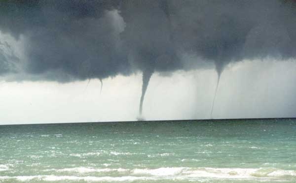
Though these look a lot like tornadoes they’re actually waterspouts, a phenomenon that fascinates me because I rarely see it.

Waterspouts don’t occur in Pittsburgh because they require lots of open water and just the right weather conditions.  The best place to see them is in the Florida Keys but you don’t have to go that far at this time of year.  They also form on the Great Lakes in late summer and early fall.

It’s possible to have a tornado over water, and yes it’s called a waterspout, but those are rare and dangerous.  Tornadic waterspouts spin down from above but the really cool and much more common fair weather waterspouts spin up from the water to join the clouds.  These require warm water, light winds, and humid air between the water and clouds.  They go through five stages as described on this NOAA webpage:

  1. Dark spot: A light-colored circle appears on the water’s surface surrounded by a dark area.
  2. Spiral pattern: The dark spot spins and forms a spiral on the water around it.
  3. Spray ring: The spinning makes water spray up around the dark spot.  The spray forms a small “eye” like the eye of a hurricane.
  4. Mature vortex:  The spray ring gets organized and moves up to join the cloud.  Now it looks like a waterspout.  Sometimes you can see through its hollow center.
  5. Decay: The funnel and spray vortex dissipate as warm water stops feeding them.  The waterspout disappears.

The frequency of waterspout sightings on the Great Lakes has increased since NOAA began tracking them in 1957.  There was a big outbreak of them on all five lakes September 27 to October 3 in 2003.

To learn more about waterspouts watch this dramatic video on the NOAA website.


(photo from NOAA by L. Glover.  Click on the image to see the original)


Where Not To Play Outdoors

NASA satellites have uncovered fascinating things about our world.  One of them is shown on the spinning colored globe above.

This 15-second video is a composite map of lightning flashes observed by NASA OTD and LIS instruments from April 1995 through February 2003. Places with virtually no lightning are white, low levels are purple, then increasing amounts pass through the colors of the rainbow finally to red, black and white again.

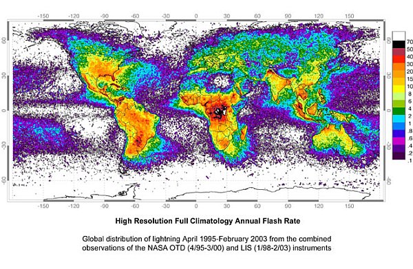
Let’s slow it down and look more closely. Here’s NASA’s static map of the same thing showing the distribution of lightning per square kilometer per year.

It’s interesting to note the hot and cold spots:

  • Lightning is far less frequent over water than land.
  • It virtually never occurs at the poles.
  • Winter is a great lightning suppressor.  I can count on one hand the number of times I’ve seen lightning while it’s snowing.  Those times were quite memorable.
  • The worst place for lightning in the U.S. is Florida.
  • Be careful in Singapore, northern Columbia, and Kashmir.
  • There’s so much lightning in equatorial Africa that the map-maker ran out of colors!

Clearly it’s unsafe to play outdoors in the DR Congo.  It’s hard to imagine how people cope with it there.


(lightning map from Goddard Space Center lightning study, 2003.  Spinning globe created from NASA lightning map and posted on YouTube by “scienceonasphere.”)


p.s. We had some sneaky lightning yesterday afternoon. A downpour, then the rain stopped and while everything was dripping… BAM! It sounded like an explosion. I’m glad I was indoors.

The Prevailing Wind

Wind-shaped trees in Wales (photo from Wikimedia Commons)

8 August 2012

Except during storms, Pittsburgh is not a very windy place.  This is especially true in July and August when our average wind speed drops to 9 mph and is usually from the west.

The direction of the “usual” wind is called the prevailing wind and it shapes our weather, rainfall, landscape and vegetation.

In places where the wind is strong the prevailing wind can be seen even when it isn’t blowing.  Witness the trees in the photo above at Cardigan Bay in Wales.

On a global basis the prevailing wind is influenced by the earth’s rotation.  As the earth spins the atmosphere swirls in a consistent way:

  • From the equator (0o) to latitude 30o north and 30o south the prevailing winds are from the east.  These are the trade winds that brought Christopher Columbus and cattle egrets(*) to the New World.
  • From latitudes 30o to 60o the prevailing wind is from the west.  The westerlies returned the trading ships to Europe.
  • From latitudes 60o to the poles the prevailing wind is again from the east.

At any given point on earth the prevailing wind might not obey these rules due to location at a border latitude (30o, 60o), topography, or seasonal change.

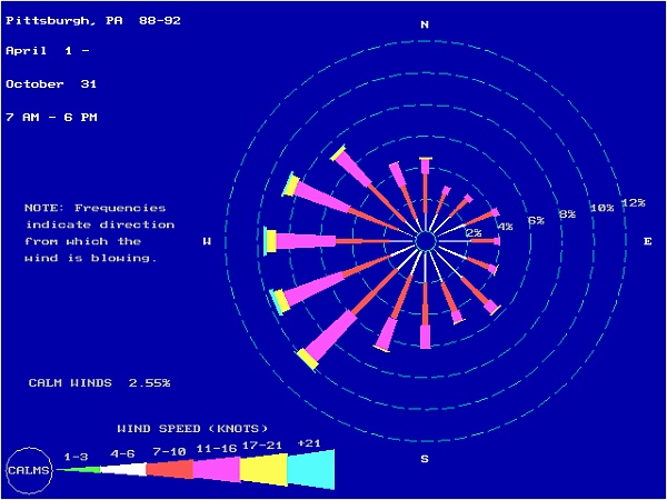
Pittsburgh, at 40oNorth, has no stark topography so our prevailing wind obeys the general rule:  it’s from the west or WSW.

We can see this on a wind rose that plots wind direction over time. Each data point is placed at its compass position.  The more data points from that position, the longer the ray from the center.

Here’s a Pittsburgh wind rose from EPA showing our daytime wind for the seven months of ozone season (April 1 to October 31).

Windrose for Pittsburgh, PA during Ozone season, April-to-October (image from EPA)

Click here to see a wind rose depicting 30 years of data on Pittsburgh’s wind direction and here for the wind roses of 11 secondary airports (smaller towns) in Pennsylvania.

And what’s the wind like for those trees in the photo above?  Right now it looks like this (scroll down to see the label “Cardigan Golf Club” and watch the wind swirl around the UK).

* Cattle egrets are originally from Africa.  They flew to South American on their own — perhaps in a strong storm carried by the prevailing winds — the trade winds.

(photo of wind-shaped trees by Rudi Winter from Wikimedia Commons. Wind rose from epa.gov. Click on the captions to see the originals.)

Looking Forward To A Little Less Lightning

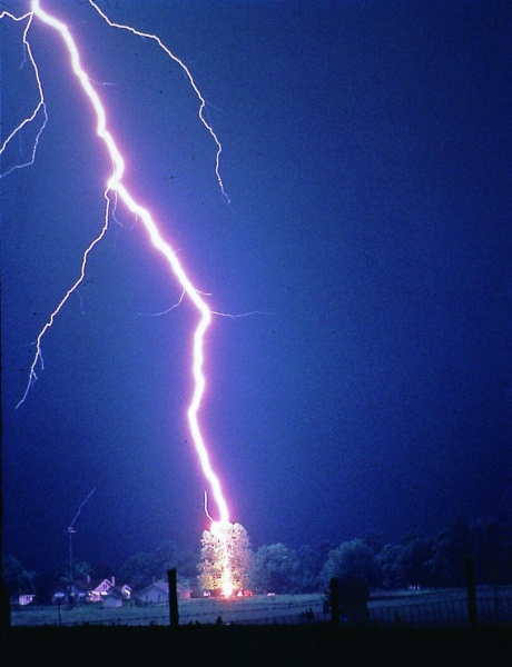
Lightning hits a tree (photo from Wikimedia Commons)

1 August 2012

Now that it’s August we’ve safely passed the month with the most lightning-related deaths and injuries.

July wins that award because it has the most thunderstorms and the storms are sneaky, popping up suddenly rather than arriving with a front in an orderly fashion.  Forecasters can’t predict the timing of these pop-ups; they can only tell us they’re likely.  And so we unintentionally take chances outdoors.

The photo above shows what happens when lightning strikes a tree.  Sadly, just over a week ago a nine-months pregnant Amish woman was killed by lightning in Somerset County when she took shelter under a tree.  Her husband and children were under a different tree and were unharmed — a cruel fate for all involved.

Fortunately, death by lightning is a rare occurrence.  90% of the people struck by lightning survive, but they are often injured for life.  Lightning damages the body’s electric grid — the nervous system — so the chronic pain, brain-injury and post-concussion-type symptoms can be very mysterious and seem unrelated to lightning.  Steve Marshburn was so frustrated by how little his lightning ailments were recognized that he started Lightning Strike and Electric Shock Survivors International which holds an annual conference for survivors and their families.

I’m not sure if Shenandoah National Park Ranger Roy C. Sullivan ever attended but he did win the dubious honor of being the person struck most often by lightning who survived the ordeal.  He was struck seven times.  Here’s his story from Virginia Thunderstorms and Lightning by Barbara Watson, originally on the NOAA website.

"June 26, 1977 Park Ranger Roy C. Sullivan worked many years at Shenandoah National Park. On this day, Roy was struck by lightning for the seventh time earning him the title of "the human lightning conductor." The first time occurred in 1942 as he was working up in a lookout tower. The lightning bolt caused him to lose his big toe nail. In 1969, he was driving along a mountain road when the bolt struck. (Cars and trucks will not protect you if the window is open). He lost his eye brows. In 1970, he was walking across his yard to get the mail when lightning struck. His shoulder was seared. In 1972, he was standing in the office at the ranger station when lightning set his hair on fire. In 1973, after his hair had grown back, he was struck again. His hair was again set on fire and his legs were seared. In 1976, while checking on a campsite, he was struck injuring his ankle. His last and seventh encounter was while fishing. Lightning caused chest and stomach burns. It is not only amazing that Roy was injured seven times by lightning, but it is astounding that he was not killed! His death in his 70's was not related to lightning. He committed suicide. It was never determined why lightning seemed to be attracted to him."

This month we’ll have a little less lightning, but we’re not out of the woods yet.  There are thunderstorms in our future.  Be careful.

(photo in the public domain from Wikimedia Commons.  Click on the image to see the original)

p.s. We had impressive lightning in the middle of the night (1 August 2012) — so impressive it woke me up.

Drought As A Technical Term

A week ago it was clear that the western edge of Pennsylvania was in a drought and it was likely to get worse.

On Thursday July 19, NOAA released its weekly Drought Monitor map and Pennsylvania DEP declared a Drought Watch for 15 western counties including Beaver County where the 90-day rainfall deficit was 5.5″ and Lawrence and Mercer where it was 4.9″.  On that day in Pittsburgh our deficit for the past 49 days (June 1) was 3.62″.

The Drought Watch called for a voluntary 5% reduction in water use and puts large water users (industry and water companies) on notice that they should plan for reduced water intake.

The situation was bad.

And then it rained — hard — three days in a row.   Almost 2″ of rain fell near the airport July 18-20, probably more than that in the city.  The streams in Schenley Park were flowing, the grass turned green, and the ground was muddy.  Ah, rain!

But we shouldn’t get too cocky.  Technically speaking, we are still under a Drought Watch and there’s reason to keep it that way.  Three days of rain may have been a temporary respite.

Last Thursday NOAA’s Climate Prediction Center also released the U.S. Seasonal Drought Outlook for July 19 through October 31, predicting where drought would persist, develop or improve.   All of western Pennsylvania and half of West Virginia are slated to become drier in the next three months as shown on the map below.

The scary part, as Georgia, Indiana, western Kentucky and the western U.S. know, is that drought breeds drought.  When the soil and plants are very dry, there is very little evaporation and transpiration and the dry air “tends to inhibit widespread development of or weaken existing thunderstorm complexes” so the thunderstorms pass us by.   According to NOAA’s forecast discussion, “It would require a dramatic shift in the weather pattern to provide significant relief to this drought, and most tools and models do not forecast this.”

So we hope for the best and look for this week’s revised outlook on Thursday.

Meanwhile, when I look at the maps I almost feel survivors’ guilt for having had some rain last week while other parts of the U.S. are suffering.

(images from National Drought Monitor Center and the National Weather Service Climate Prediction Center.  Click on the images to see their source)

July 24, 1:30pm: Two downpours today! When I write about drought it rains.

Less than a month later, August 16, 2012: The revised drought forecast takes Pennsylvania out of the drought zone.  See below.
Aphelion Today

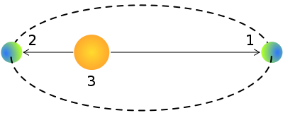
Today the Earth reaches its furthest point from the Sun in its annual orbit.  This is Earth’s aphelion, position 1 above.

It’s a source of wonder to me that this happens at our hottest time of year.  Shouldn’t aphelion cool things off?

Apparently not by much.  The orbit determines Earth’s livability but has far less affect on temperature than the composition of our atmosphere and the tilt of the earth’s axis.  Right now the northern hemisphere is tilted toward the sun and we certainly feel it.

If we had the data and computer horsepower we could prove aphelion’s effect on climate because it hasn’t always occurred in July.

According to Wikipedia, “On a very long time scale, the dates of perihelion and aphelion progress through the seasons and make one complete cycle in 22,000 to 26,000 years. There is a corresponding movement of the position of the stars as seen from Earth that is called the apsidal precession.”

So, hey, if you’re around 12,000 years from now, aphelion will happen in December.

It’s something to look forward to.

(drawing of aphelion and perihelion by Peasron Scott Foresman via Wikimedia Commons)

Panting

Egad it’s hot!

The temperature is 15 degrees above normal this weekend.  Tomorrow is Memorial Day but it feels like the Fourth of July.  By 11:00am it’s not fun to be outdoors so I go inside to cool off in the air conditioning.  But birds don’t have that option.  How do they cope with heat?

They pant.

Birds’ body temperatures are slightly higher than ours — about 104oF (40oC) versus our 98.6oF.   They don’t have sweat glands so they lose heat in other ways.  Dorothy’s showing us how in this photo taken on Banding Day:

  • Sleek the contour feathers so they transfer heat away from the body rather than retain it,
  • Expose the legs (and toes in Dorothy’s case) to let heat leave the skin,
  • Hold the wings away from the body,
  • And pant.

To keep heat at bay birds hide in the shade or soar high into cooler air.  Some large birds, such as vultures, cool their legs by excreting on them.  The small birds in my backyard cool their legs by hopping into my birdbath.

The Pitt peregrine chicks can’t fly to a birdbath, but you’ll see them on camera hiding in the shade and panting.

Until the weather breaks we’re all looking for relief.

(photo by Donna Memon)

Difficult Weather

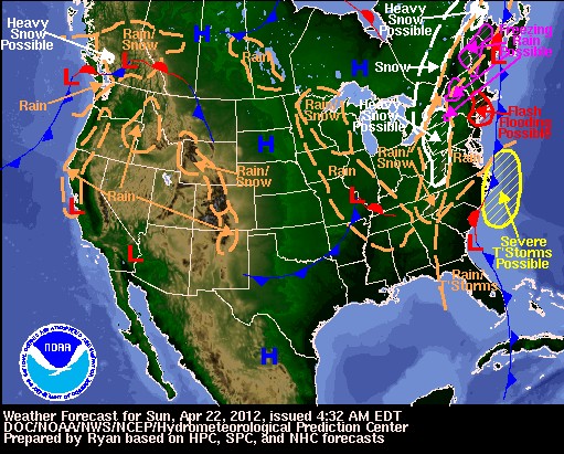
Yesterday morning the weather forecast for the eastern U.S. looked like a train wreck with severe thunderstorms, flash floods, heavy snow and freezing rain.

These events were listed as “possible” because the approaching storms were so complicated.  The depth of snow in Pittsburgh depended on the timing of two frontal systems approaching the east coast from different directions.  Would they collide and merge their forces over western Pennsylvania?  Would the coastal front stay to the east and not affect Pittsburgh?  Would the systems cause a single large storm or a prolonged one-two punch?  And where?

The National Weather Service uses many weather modeling systems to make their predictions, primarily NAM (North American Mesoscale Forecast) and GFS (Global Forecast System).  Both NAM and GFS run four times a day.  Meteorologists then analyze the results and make the forecast.  When the models agree it’s easy.  When they don’t it’s mighty hard.

Yesterday the forecast discussion for Pittsburgh said:  “Even at this close proximity to the onset of this system, subtle differences in model solutions make for a very difficult forecast.”   Then they predicted 2 to 4 inches of snow for the Pittsburgh area. Twenty-four hours later the snowfall prediction hasn’t changed but its timing has.

I feel their pain.  Because I’m in charge of computers and phones at WQED, I’m often asked to predict how a computer or phone system will behave under different conditions in the future.  Sometimes the answer is easy and sometimes… Well, suffice it say I’m glad my predictions aren’t broadcast on TV and radio news.

Meanwhile we await the results.  Rain is falling now.  It will be interesting to see how well the models predicted this one.

(weather forecast map, Sunday 22 April 2012, by the National Weather Service. Click on the image to see the current forecast map.)

Fire Season

Spring is fire season in Pennsylvania.

85% of Pennsylvania’s wildfires occur in March, April and May, not because it hasn’t rained but because it’s windy and the old leaf litter provides a lot of fuel before the new leaves are out.

In Pennsylvania almost all wildfires are caused by people, so from March 1 to May 25 DCNR prohibits open fires in the State Forests.  This burn ban is instituted every year.  Even so, wildfires burn 10,000 acres annually in Pennsylvania.

Spring is also the time for controlled burns to clear the fields for planting.  If you fly across the U.S. on a clear, windless day this month you’ll see the smoke of controlled burns across the country.

Fire is the “natural” solution for clearing large fields when it’s impractical to till the old plants into the soil. But fire is not welcome near residential areas because of the smoke.  In western Pennsylvania I can tell that farmers often use herbicide because I find stark brown fields in April, surrounded by bright straight lines of green plants along the edges.

I’m not wild about herbicides.  If it weren’t for the smoke I’d prefer fire except …

Sometimes controlled burns go out of control as one did last week in Colorado.

Be careful.  It’s fire season.

(photo by Richard Chambers of a controlled burn in Statesboro, Georgia via Wikimedia Commons.  Click on the photo to see the original)