Category Archives: Weather & Sky

The New Normal: Too Early Spring

Cutleaf toothwort (photo by Dianne Machesney)

21 March 2012:

One day does not a summer make but a week of June-like weather is mighty convincing.

Though I’m thrilled to be wearing summer clothes in mid-March it makes me very worried.  Our temperatures have been 20 to 30 degrees above normal.  In Minnesota the morning low in International Falls tied the previous record high on Monday!

The heat is unprecedented and the landscape is responding.  Last Sunday I found cutleaf toothwort (pictured above) blooming four weeks ahead of schedule and yellow buckeye trees leafing out in Schenley Park (below).   The weather is three months early.  The plants are one month ahead.

Yellow buckeye full leaf, 20 March 2012 (photo by Kate St. John)

Insects are responding as well.  Stink bugs are everywhere and I swear I heard a cricket last night.

Most birds can’t keep up.  Those already here are moving north a bit early but the bulk of the migrants are in Central and South America and have no idea our weather is so far ahead of schedule. When they get here they may find their peak insect food resources have passed.

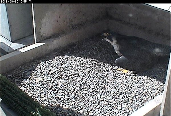
Meanwhile peregrines lay their eggs so that hatching will coincide with the push of northward migrants.  Dorothy’s first egg is right on time though the heat is not.  It was sad to see her panting at the nest yesterday, trying to keep her egg cool so it won’t develop out of synch.

Dorothy gular fluttering to dissipate heat, 30 March 2012 (photo from the National Aviary snapshot camera)

With a warm winter here and a very cold winter in Europe, we’re on the roller coaster of climate change.  Arguing about it is pointless now.  Ready or not, we’re already experiencing the new normal.

(Cutleaf toothwort photo by Dianne Machesney.  Yellow buckeye leaves by Kate St. John.  Dorothy panting at her nest on 20 March 2012 from the National Aviary falconcam at Univ of Pittsburgh)

Atmospheric Effects

Yesterday the sky attracted my attention.

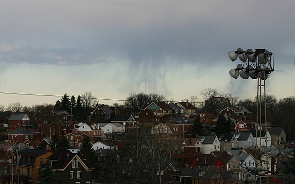
In the morning I saw thin lines of rain hanging from the clouds without touching the ground.

Virga!

Virga means “rod” in Latin and is the name for precipitation that evaporates before reaching the ground.  It’s very common out West where the air is dry and virga’s rapid evaporation causes high winds.

I tried to take a picture but the best of the virga drifted behind the ballpark lights.  In the middle of the photograph you can see “rods” falling and curling from the cloud.  Moments earlier there was more separation between the rain and the ground.  I just wasn’t quick enough.  Click here for a much better picture of virga.

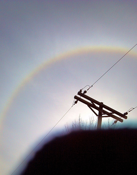
The sky cleared at midday, then high, thin clouds moved in ahead of a cold front.  Way up there, above 20,000 feet, the air was filled with tiny ice crystals that caused an optical effect — a halo around the sun.

Halos are circular pastel rainbows that occur when sunlight passes in one side of the hexagonal ice crystals and out another side.  The light is doing this all over the sky but we typically see halos at 22o from the sun (or moon), though other angles are possible.

I can tell you it’s hard to take a halo’s picture because the sun confuses the camera.  I tried to block the sun with a telephone pole but that wasn’t enough.  I had to use my mitten too, so this photo is odd.

Click here for a better picture of a halo.

Keep looking up.  You may see some atmospheric effects.

(photos by Kate St. John)

.

.

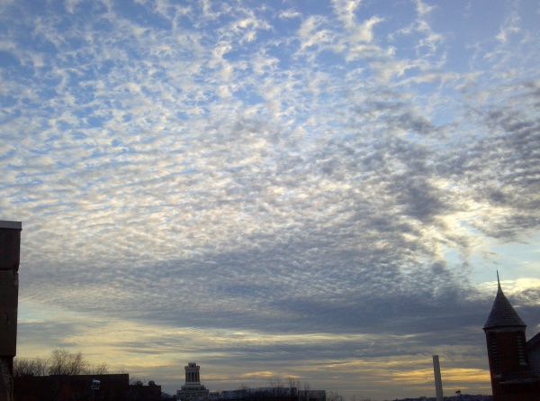
p.s. Late on Monday afternoon we had a mackerel sky (shown below).  Can you guess why it’s called that?

Solar Excitement

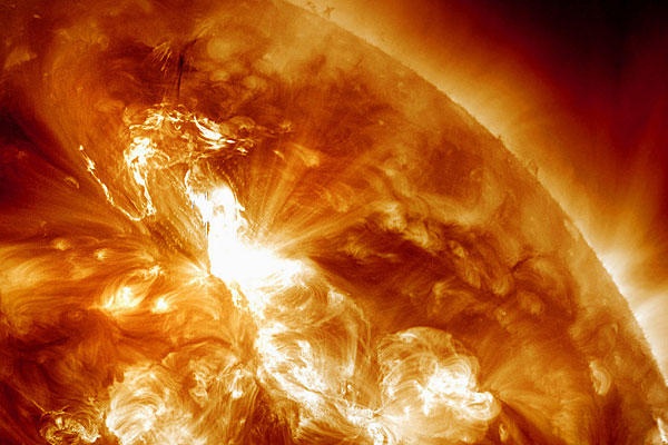
Solar flare at Active Region 1402, 23 Jan 2012, 0349 UTC (image from NASA SDO in the public domain)

28 January 2012:

Last weekend’s solar flare made the news with beautiful images from NASA’s Solar Dynamics Observatory.

On January 23 at 4am UTC (January 22 11pm in Pittsburgh) a huge “burp” of charged particles and magnetic fields burst off the sun from Active Region 1402.  The wave traveled at 2,200 km/second — 150 times slower than the speed of light — so we saw it before we “felt” it on January 24 around 1400 GMT (January 24, 9am EST, plus or minus 7 hours).

Major pulses from the sun can cause outages in the electric grid and interference with radio and TV broadcasts and communication devices.  The episode I best remember was when a pulse killed Telstar 401 and stopped PBS broadcasting until they could find a new satellite and we re-pointed our station dish.

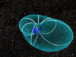
Earth’s magnetic field protects us from these “burps” but it gets distorted while doing so.  In normal times the solar wind squashes our magnetic field on the earth’s sunward (day) side and elongates on the night side.  Here’s a diagram from NASA showing how that works with the sun positioned at top left.

Diagram of Earth’s magnetic field (image by NASA, in the public domain)

In a solar flare event the magnetic bulge on the night side gets longer, the loops break and they “flap in the breeze.”  When the field snaps back it releases energy that whacks the earth’s upper atmosphere, causing the beautiful northern lights and sometimes electro-magnetic interference.

Meanwhile nothing much happened here on Earth except …

On Tuesday morning January 24 around 7am, an electrical transformer at WQED blew up and burned.  It was quickly extinguished and the damage was minor, but it left us without electricity.  Thanks to our generator we remained on the air and on the web.  All day Tuesday and into the night, the electricians worked hard to hook up a temporary power feed.  Unfortunately, when they switched us back to house power on Wednesday morning at 2am an internal surge tripped a breaker on our emergency grid and we went off the air and off the web.

So it’s been an exciting week for us in technology at WQED.  The flare probably didn’t cause our electrical problem but the timing was quite a coincidence.

Watch what happened on the sun in this cool video from NASA SDO:

(All photos from NASA. Click on the images to see the originals.)

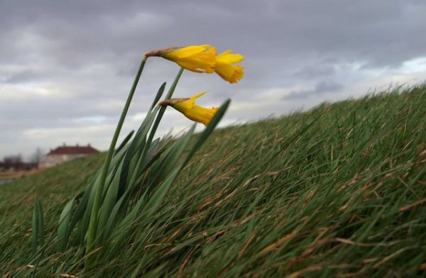
Winds Gusting to 50 Miles Per Hour

Today’s forecast in Pittsburgh calls for a rainy high of 53o followed by a strong cold front with winds gusting to 35 mph overnight.  North and east of here the wind will be even gustier, up to 50 mph in Dubois and Johnstown.

So I wondered… What causes wind gusts?  And what will cause them tonight?

Wind gusts are quick bursts and lulls of wind (we know this) lasting 20 seconds or less.  The National Weather Service doesn’t even call it a gust until it reaches 18 mph and has a 10 mph difference between burst and lull.  If the gust lasts a minute it’s called a squall.  If it lasts longer than that it’s real wind, a gale or a hurricane.

Weather experts say gusts are caused by three things:  turbulence from friction, wind shear and solar heating.

We can rule out solar heating today but I’ve seen it in summer when rising hot air is quickly replaced by cold air dropping to fill its place.  In the desert the gusts are amazing.

Wind shear occurs at the unseen three dimensional boundaries where wind speed and direction change within a short distance.  If the wind could hold colored dots wind shear would be an amazing visual effect, an edge where a slow wind moving one way meets a faster wind moving another direction.  Aloft these gusts cause a bumpy airplane ride, but they’re dangerous near the ground where there’s no vertical distance to recover from the bump.

I don’t know if wind shear is a factor in tonight’s weather but I suspect not.  It wasn’t mentioned at all.

On the other hand I’m sure turbulence from friction is involved.  Today’s cold front is moving in very fast with 60 mph winds at 2000 feet.  At higher elevations, such as the Laurel Highlands, the 60 mph wind is a lot closer to the ground. If even a fraction of it scrapes the earth the friction will cause gusts.

Turbulence is even greater near cliffs and buildings where the wind rushes faster through narrow openings, causing whirls and eddies that raise leaves and trash high into the sky.  I experience this all the time at the Cathedral of Learning.

Tonight the peregrines won’t find it pleasant to roost up there, but they’re used to the wind.  “Ho hum,” they say.  “This wind is nothing.”


(photo by Steve F. from Wikimedia Commons. Click on the photo to see the original)
 

p.s. This blog post is about wind gusts but what is causing so much wind today? Read Rob Protz’ comment for an explanation.

The Cold of Exploding Trees

Winter damaged tree (photo by Randy Cyr, Greentree, Bugwood.org)

14 January 2012

Well, it’s still winter out there.  It was 18o F at dawn in Pittsburgh but by Monday it will be back to 41o.

These yo-yo temperatures can wreak havoc on roads and bridges and our landslide-prone hillsides.  If the temperature drops fast and far enough it even hurts living things.  At super-low temperatures the trees explode.

I had never heard of this phenomenon until a conversation in Maine last fall when I asked Ann Sweet at the Harbourside Inn how cold it gets in winter at Acadia National Park.  Ann said the ocean keeps the island warmer than interior Maine but every once in a while it gets so cold that the trees explode.

Wow! And why?

Tree sap contains water and water expands when it freezes.  The expansion increases pressure under the bark and in extreme cases causes the bark to explode.  This doesn’t happen all the time because trees draw down sap into their roots in autumn, leaving room under the bark for expansion.  If they didn’t do this they wouldn’t live through the winter.

The danger for cold-explosion comes when the trees haven’t had time to draw down their sap or when the temperature falls extremely low.  Both occurred in north-central Washington state in December 1968 when temperatures fell to -47oF.  The fruit trees in Wally and Shirley Loudon’s orchard exploded.

Native Americans were well aware of this phenomenon.  According to Wikipedia, the Sioux and Cree called the first full moon of January “The moon of cold-exploding trees.”

When the moon was full on January 9, Pittsburgh’s average temperature was 10 degrees above normal.  I don’t think we’re in any danger of exploding trees.

The Golden Hour

The golden hour, Dörflingen, Switzerland, 18 December 2010 (photo by Hansueli Krapf from Wikimedia Commons)

22 December 2011

Today is the southern solstice, the day of shortest sunlight in the northern hemisphere and the longest golden hours.

In photography, the golden hour is the period just after sunrise and just before sunset when the sun is low in the sky.  In that position it passes through more of the earth’s atmosphere so its light is reddish and diffuse and the shadows are long.

I learned about the golden hour when I looked up the time for sunrise and found additional information. Though there are many definitions for it the most common is that the golden hour ends when the sun is more than 6 degrees above the horizon.

Today in Pittsburgh the sun will rise at 7:40am and set at 4:57pm for 9 hours 17 minutes of daylight.  In the morning the sun will be low in the sky until 8:23am. In the afternoon it will reach the golden hour at 4:13pm for a total of 97 minutes of golden light.  This would be lovely but we’ll never see it.  The sky is overcast.

The golden hour is more pronounced the further north you go.

In Helsinki, Finland the sun rose at 9:24am and will set at 3:13pm for only 5 hours and 49 minutes of daylight.  Most of the time the sun will just skim the horizon producing two very long golden hours.  In fact they’ll have only 80 minutes of real “day” when the sun’s above 6o.

After the solstice the days will get longer and the golden hours shorter.

Don’t miss today’s golden light.  For the best photographic effects, try Helsinki.

(photo by Hansueli Krapf  on Wikimedia Commons.  Click on the photo to see the original.)

Jupiter’s Clock


In this day of cellphone GPS applications and vehicle navigation systems we forget that knowing exactly where you are on earth used to be a huge problem.  It was especially acute at sea where there aren’t any landmarks.

Until an accurate marine clock was invented in 1737 and became affordable in the 1780’s, seaman used the position of the sun, stars and planets to determine their location.  This worked well for north and south (latitude) but was impossible for determining east-west (longitude) because the earth rotates in that direction.

Shipwrecks occurred frequently, even under the best sea captains, and kings offered enormous prizes to the person who could solve the longitude problem.  Astronomers looked for a spot in the sky that behaved predictably and independently of the Earth’s orbit.

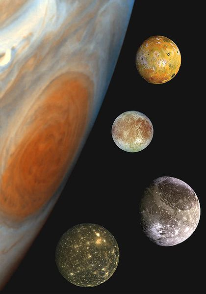
Galileo found an answer in Jupiter’s moons.

After he perfected the telescope in 1609, Galileo discovered the four largest moons of Jupiter.  He carefully logged their orbits and noted how often they disappeared behind the planet.  His records showed their orbits are so predictable you can tell time by them.  This was an answer to the longitude problem.

But it didn’t work at sea.  If you’ve ever viewed Jupiter through your binoculars you know that your heartbeat can make the planet jump.  No one could see the moons’ eclipses on a rolling boat deck.  However the method worked well on land with a tripod.

By 1650, the eclipses of Jupiter’s moons were so well documented that mapmakers used them to redraw the world.  Finally there were accurate land maps!  King Louis XIV of France reportedly complained that he was losing more territory to his astronomers than to his enemies (*).

Twenty-six years later Jupiter helped calculate the speed of light when Danish astronomer Ole Rømer discovered that the eclipses occurred sooner than expected when the Earth was closest to Jupiter and later than expected when Earth and Jupiter were furthest apart.  The difference is the speed of light.

Today Jupiter will rise at 2:00pm but his transit will go largely unnoticed.  His moons still keep accurate time but his role is eclipsed by our wristwatches, cellphones and satellites.

.

(Composite photo of Jupiter with its Galilean moons by NASA on Wikimedia Commons.  Click on the image to read how it was constructed.)

.

(*) This quote is from Dava Sobel’s book, Longitude: The True Story of a Lone Genius Who Solved the Greatest Scientific Problem of His Time, where I learned these facts about Jupiter.  I highly recommend her book, published by Penguin in 1995.  Click on the book link to find it on Amazon.

There’s Something In The Air

As I’ve snapped photographs of bark for my winter tree identification series, I’ve had no trouble finding clean, lichen-free trees in Schenley Park.  It turns out the lack of lichens is bad news for our air quality.

Lichens are two organisms that operate as one, a symbiotic partnership of a fungus with a green or blue-green algae (sometimes all three).  The algae’s photosynthesis feeds the fungus.  The fungus gathers and retains water and nutrients and protects the algae.

This amazing combination allows lichens to thrive in some of the harshest habitats on earth but they’re sensitive to air pollution.  The ones that grow on trees are epiphytes, totally dependent on the surrounding air and precipitation for their nutrition.  Ultimately their tissues absorb elements in concentrations that mimic what’s in the air.

We’ve known for a long time that there’s a correlation between the absence of lichens and poor air quality.  Back in 1866, the Finnish botanist William Nylander showed that lichens were present in the Luxembourg Gardens that had disappeared from the polluted sections of Paris, France.  Sadly, air pollution increased in Paris and within 30 years the Luxembourg Gardens’ lichens had disappeared as well.

Lichens are used in air quality studies today because they are widespread, accurate indicators and far less expensive than man-made monitors.  You don’t have to be an expert to participate.  In the 1960’s schoolchildren in Great Britain gathered data in a nationwide lichen-based air quality study that produced the “Mucky Air” map.  Here’s a list of a few more recent lichen studies:

Even if you can’t identify lichens you can make a rough guess of the local air quality by the types of lichens you see.  Basically, “the further it stands out from the tree, the cleaner the air.”  Crusty lichens (crustose) are the hardiest because they have the least surface area, leafy (foliose) lichens are in the middle, shrubby (fruticose) lichens are the most sensitive.  Hypogymnia physodes, a foliose lichen pictured above, is often used as an indicator species because it’s widely distributed and it “stands up.”  I’ve seen lichens like this in Maine but not in Pittsburgh.

Lichens are especially sensitive to sulfur dioxide (SO2).  So are people.  In Pennsylvania most of our SO2 is produced by coal-burning power plants and coking facilities.   High SO2 causes respiratory distress and triggers asthma so it’s been regulated since the Clean Air Act of 1970.  Lichens have rebounded in many areas of the U.S. since then.

In June 2010 EPA issued tighter 1-hour SO2 standards (75 ppb, measured hourly) to protect public health from high short term exposures ranging from 5 minutes to 24 hours.  Because we’ve been measuring SO2 for so long, we already know that the Pennsylvania counties of Allegheny, Beaver, Indiana and Warren have exceeded the new SO2 standard.  Coal-burning facilities in these counties will have to control their SO2 emissions even further.  As they do, we’ll all breathe a little easier.

And we’ll have more lichens in the future.

(photo in the public domain from Wikimedia Commons. Click on the photo to see the original.)

Sky Shadow, Tyndall Effect


How can a building cast a shadow on the sky?  The label on this photograph explains it:  Tyndall effect at CN Tower, Toronto.

The Tyndall effect was new to me so I looked it up.  Named for physicist John Tyndall (1820-1893), it describes how light is scattered as it passes through a colloid.

A colloid is a gas, liquid or solid that has particles microscopically and evenly dispersed within it.  Both natural and man-made colloids exist.  Some natural examples are fog, smoke, milk and gelatin.  Opals are colloids whose beauty comes from the Tyndall effect.

In this photo the air is a colloid.  Some of the particles in it are natural (water droplets and dust), some are man-made (fine particulate pollution that generates smog).  In either case the particles scatter sunlight and we can see the beam of sunlight.

Despite reading a lot about it I didn’t really understand the Tyndall effect until I watched this educational video.  The narrator first shows that a laser beam cannot be seen as it passes through plain water.  Then he puts two drops of Dettol (a cleaning product) into the water and the laser beam appears.

Pretty cool, huh?

So when you see a shadow on the sky, you know there’s something in the air.

(photo by Wladyslaw, a featured picture on Wikimedia Commons. Click on the photo to see the original.  Video posted by ksvsrao on YouTube.)

First Hard Frost


On Friday we had the winter’s first hard frost in the city.

I say this based on my observation of the plants in Schenley Park.  Prior to December 1 we’d had some lightly frosty mornings and one big snowfall in late October, but no frost so hard that the plants broke under it.  Some non-native species continued to bloom.

On Friday the plants broke.  On Saturday the frost peristed until the sun turned it into swirling steam.

Winter is officially here.

(photo by tracy from Wikimedia Commons)