On Friday we had the winter’s first hard frost in the city.
I say this based on my observation of the plants in Schenley Park. Prior to December 1 we’d had some lightly frosty mornings and one big snowfall in late October, but no frost so hard that the plants broke under it. Some non-native species continued to bloom.
On Friday the plants broke. On Saturday the frost peristed until the sun turned it into swirling steam.
This year my friends and family have had more than their usual share of destruction from the few hurricanes that hit the United States. Hurricane Irene and the remnants of Lee have been headline news for weeks and Hurricane Katia, who’s missing the U.S. entirely, is affecting friends on a cruise in Greenland.
So I wondered… how and why do hurricanes form? I did a little research and found that even the basic facts are fascinating.
Hurricanes are tropical cyclones, complex dangerous storms that occur around the world. In the North Atlantic and on the eastern side of the Pacific we call them hurricanes. In the northwest Pacific they’re called typhoons.
Tropical cyclones are not completely understood but scientists know that six ingredients are required for a hurricane to form. The ingredients, listed at NOAA, are:
A warm ocean surface of at least 79.7oF to a depth of 160 feet. To get an idea of how warm this is, the water temperature at the Eastern Maine Shelf this morning is 54-52o from the surface to 160 feet.
Rapid cooling of the air as it moves upward, causing condensation and thunderstorms which release heat to drive the storm.
High humidity in the mid troposphere 3 miles (15,800 feet) above the ocean. If you were on a trans-Atlantic airplane, you’d be flying high above it.
The Coriolis effect must cause the storm to spin. There is no Coriolis effect at the equator so the storms cannot form at less than 50 of latitude (345 miles) from the equator.
A pre-existing disturbed weather system near the ocean surface which provides the nascent storm with something to organize around.
Low wind shear where the storm is forming. Wind shear is an abrupt difference in wind speed and direction and can break up a cyclone before it gets going.
In August and September hurricanes often form off the Cape Verde Islands near the north coast of Africa. They are then carried by the trade winds across the Atlantic and sweep over the Caribbean islands and sometimes the U.S. or Central America. Right now Tropical Storm Maria is heading for Puerto Rico and Tropical Storm Nate is about to hit Mexico.
Thank heaven we’re over the hump of hurricane season for 2011. We’ve certainly seen enough of them this year.
(satellite image of Tropical Storm Katia from NASA’s MODIS Rapid Response System on 31 Aug 2011. Click on the image to see the original at Wikimedia Commons)
Last Friday afternoon our basement floor was briefly lower than the water table.
At 3:45pm Friday a violent thunderstorm moved so slowly over Pittsburgh that it dropped as much as 2″ of rain within half an hour. Flash floods filled the streets, stranded motorists, and drowned four people on Washington Boulevard (tragic and awful!).
But I didn’t know that at the time. I was at work, watching a huge muddy lake form over Central Catholic’s parking lot and football field. Definitely not a good sign. I decided to stay at my desk.
By 5:00pm the lake was gone so I went home. On the way there I thought about the basement.
Our 104-year-old house is built into the side of a hill with the back of the basement below ground and the front above. Though it’s not prone to flooding, very heavy rain (Hurricane Ivan) leaks in from above by following the electric and air conditioning chaseways. When I got home I took a look.
It’s a good thing we’ve never “finished” the basement. Its concrete floor was poured after the house was built and is uneven. A minor flood had gone down the drain but I was able to mop up a gallon from the low spots. Then I set up fans to dry the floor.
On Saturday morning I examined my handiwork. The floor was dry but the base of the back wall was still damp. Aha! Some of the water was behind that wall. How did I not notice this before?
I wasn’t paying attention. The water table is the top of the zone where the subsurface is saturated with groundwater. It rises and falls as groundwater is added — or not added — by rainfall and snow melt. When it rises above the low spots on the surface, streams and rivers form. On Friday afternoon before I got home a little stream was in my basement.
I’m glad I wasn’t there when it was happening. I’m glad I wasn’t on the road either.
It’s not good to be in the zone of intermittent saturation.
(image from Wikimedia Commons. Click on the image to see the original.)
Ladies of my grandmothers’ generation never felt hot and sweaty. They may have perspired but they never called it sweat. Instead they “felt dewy.”
We’ve all been feeling dewy lately. The humidity has been so thick in Pittsburgh that we’ve been cloaked in haze for days. When we step out the front door at dawn it feels hot even though it’s only 73oF.
Temperature has been no guide when choosing what to wear. 73oF outdoors is oppressive; 73oF on an air conditioned bus is freezing!
My niece Kelley, who grew up in south Florida, gave me a tip on what to listen for in the weather report: Dewpoint is the number to watch. If it’s 70oF or more you’re going to feel hot.
The dew point is the saturation temperature, the point at which dew will form if the air pressure remains constant.
Our bodies cool by evaporating perspiration from our skin. When the dewpoint is over 70oF we perspire but the dampness doesn’t evaporate and we still feel hot. The weather’s oppressive even though the temperature sounds comfortable.
Since Kelley told me about dewpoint I’ve been paying attention to it. This morning it was 69oF.
Monday morning a storm was brewing when I looked out the window and saw a roofer walking on Central Catholic’s steep slate roof. He and his crew had come to replace a few bad slates.
I have a healthy fear of heights and lightning so I was morbidly fascinated. Would they be macho about the approaching storm or would they leave?
Two of them were up there when a brief downpour swept by. The roof became slippery. They sat down.
The next time I looked the crew was off the main roof waiting on a lower level while the boss walked the ridgepole. He examined the approaching black cloud with professional interest. There was lightning in it. He pointed out the cloud’s leading edge to the crew as it slowly moved south. Would he get off that roof?!?!
I know enough about lightning that I didn’t want to see what might happen. I stopped watching.
In most years lightning kills more people than tornadoes and hurricanes combined. (This year’s Joplin tornado turned that statistic on its head.) Most people survive lightning strikes but have lifelong health problems afterward. Most people are hit by lightning when it’s not raining — probably because they don’t take shelter unless it rains.
I avoid lightning and have learned that…
The safest place to be is in an enclosed building that has plumbing or wiring (or lightning rods!) or in a car with a metal roof (not a convertible).
Lightning hits tall objects (don’t stand under something tall; don’t be tall yourself) and it travels through the ground (don’t lie flat; don’t stand near metal fences).
A friend once told me a harrowing story of being in a rustic cabin in Canada during a nighttime thunderstorm. Lightning repeatedly hit the ground and came up through the floor. It made the bedsprings glow. Yikes!
My worst scare was the time I parked at the top of Laurel Mountain and hiked down the Tebolt Trail at Quebec Run Wild Area. Thunderstorms were predicted to arrive at 2:00pm but I lost track of time. At 1:00pm I heard thunder and knew it would take at least an hour to walk back up the mountain no matter how fast I went. I started to walk and run uphill. By the time I reached the top of the mountain the storm was quite close and I was praying and bargaining, “Not now! Please wait!” I made it to the car, slammed the door and “BOOM!” The lightning didn’t hit me but my heart sure beat fast!
I could never be a roofer.
And, yes, the roofers left before the storm.
p.s. Do you have any close calls with lightning? As I said, I’m morbidly fascinated.
The weather has moderated a little, but it’s still hot and humid.
I’d like to go hiking but southwestern Pennsylvania has a 50% chance of thunderstorms today and I won’t go out there in lightning if I can avoid it.
Now it looks unavoidable. The sky has become ominously dark as I write.
If the weather was merely hot I’d visit Cucumber Falls, pictured above. The falls are part of Cucumber Run in Ohiopyle State Park and they’re easy to get to. There’s a parking lot near the falls for a quick visit, or you can get a better look at Cucumber Run by hiking the Great Gorge Trail. Hike upstream to feel the cool air in the creek valley or walk downstream to the Youghiogheny River where you can watch the rapids. Here’s a map of the park. (The map takes a while to download. If it looks black, change the zoom and the map will appear.)
Unfortunately Ohiopyle is a 90 minute drive from Pittsburgh and I can’t see driving that far to wait in the car for a storm to pass.
I guess I’ll have to stay close to home and merely think cool thoughts.
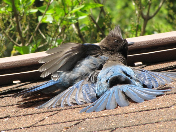
Steller’s jays sunbathing (photo by Michelline Halliday)
It looks like these Steller’s jays are overcome by the heat but they’re actually sunbathing on Michelline Halliday’s roof in Seattle.
Today is the wrong day to sunbathe in Pittsburgh! The high will be 94oF but the heat index will make it feel like 102o. Last night at 9:00pm it was still 89o with a heat index of 97o. This morning it was 80oF at dawn. And did I mention that the air will be bad? Stay indoors.
Today it will be only 69oF in Seattle. (I’m so jealous!)
Even so, it looks like one jay is saying to the other, “Hot enough for you?”
On July 1 NOAA’s National Climatic Data Center released the new U.S. Climate Normals based on 1981-2010 data.
“Normals” are a 30-year average of daily and monthly temperatures, precipitation, snowfall, snow depth, and heating and cooling degree days. We hear them every day when the weather forecast is compared to normal and they’re used to forecast energy loads, crop planting times and construction schedules, to name a few.
Every ten years NOAA recalculates the normals using an international protocol that drops the oldest decade and incorporates the most recent. On July 1, the 1970s were dropped and the 2000s included.
The result shows that the average U.S. temperature increased half a degree. 2001-2010 was the hottest decade on record — 1.5oF hotter than the 1970s — but the normals are a three-decade average so it comes to 0.5oF. Surprisingly, most of the temperature gain was through warmer nights, not hotter days. January minimum temperatures rose 5 degrees in the most northern U.S. states.
Does that half a degree matter?
Indeed it does. Warmer nights mean that killing frosts start later in the fall and end earlier in the spring. Wherever you live, the growing season is a little bit longer.
You can see this on the NOAA map above where each colored stripe represents the change in a plant hardiness zone. Pittsburgh is squarely inside Zone 6 so we aren’t in a colored stripe — yet — but northwestern Pennsylvania and the Allegheny Plateau have warmed enough to move from Zone 5 into 6. Michigan changed a lot!
You might think this is great news but there are bad side effects. If you rely on plants at the southern edge of their range, those plants are stressed because it’s too hot for them. Even if you hate winter, you’ve got to admit it’s a great pest control system. Deep freezing nights protect our plants by killing many insect pests. Sadly, pine bark beetles now thrive in Colorado and Canada because their winters are no longer cold enough to kill them.
If you’ve been gardening or farming for the past 30 years you’ve noticed the shift in temperature and you’ll be glad to know that USDA is revising their 1990 Plant Hardiness Map based on the new data.
When the new map comes out, keep it handy — but expect to need a new one in only 10 years. According to NOAA’s Climate Center, plant zones will shift dramatically by 2041. By then Pittsburgh will feel like Tennessee. We’ll be in Zone 7.
Hot, sunny weather today and tomorrow will cook up a nasty brew of ground-level ozone in the Pittsburgh area. PA DEP has cautioned that both days will be at the orange level: unhealthy for sensitive groups.
Ozone (O3) is an unstable gas that’s bad at ground level because it’s toxic but good in the stratosphere because it protects us from ultraviolet light. It’s formed when UV light acts on oxygen (O2) and other constituents to create the three-atom structure shown above.
If you have breathing problems, stay indoors.
Funny how the chemical structure of ozone looks like it’s saying “Oh No!”
Today is the spring equinox when the sun’s rays directly strike the Equator and day’s length is the same as night’s.
On Friday the warm weather felt like May, but the woods are still brown. At this time of year even the faintest sign of flowers is enough to get me excited. Here’s a list of hopeful signs I’ve seen since my last phenology report only five days ago.
Robins singing before dawn.
Canada geese flying over my house in the city.
A northern flicker drumming on the metal floodlight hoods at Magee ballfield. (He’s really loud!)
Swelling buds make the trees look denser. The red maples look hazy-red. Some trees already have tiny flowers.
New leaves on bush honeysuckle, an invasive plant that’s always first to leaf out.
Red-tailed hawks mating.
My daffodils and tulips are pushing up through the leaf litter. Today I’ll be looking for coltsfoot in bloom.
")
")
")
")
")
")

")
")